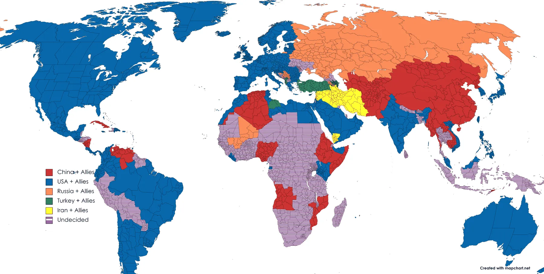
Legend, as drawn China + Allies · USA + Allies · Russia + Allies · Turkey + Allies · Iran + Allies · Undecided
The Map Drawer
Twelve sheets made in MapChart before any of this was a website, ten of them dated between March 2022 and May 2024. Six are the same map, redrawn.
Long before there was a site called The Atlas there was a browser tab open on mapchart.net. MapChart is a fill-in-the-countries tool: you pick a colour, you click a country or a province, you write a legend, you export a PNG. It computes nothing and it checks nothing. Everything below is therefore an opinion with a legend attached, drawn in high school and the first years of college, and none of it is sourced the way anything else on this site is sourced. Read the claims as a teenager's reading of the news, because that is what they are.
They are up here anyway, for one reason. Six of these sheets are the same map. From March 2022 to May 2024 I kept redrawing a single picture of who was aligned with whom, and the versions differ less in where the blocs fall than in what the legend is willing to say. That record of a model being revised is worth more than any one of the maps, and it is the only thing that earns a page of amateur MapChart fills a place on a site that otherwise cites its sources.
The legend grows from 6 categories to 9, but not steadily: 6, 6, 5, 8, 8, 9. The interesting movement is the dip. Version III is the tidiest of them and the least honest, and everything after it is the model paying for that tidiness.
3 March 2022
The first one, drawn a week into the full-scale invasion. Six blocs, one for each power I thought was running its own show: the United States, China, Russia, Turkey and Iran, plus everyone who had not picked. Russia and China have separate colours here, and that assumption is the thing the next five versions spend two years dismantling.
The other thing to notice is Ukraine. The whole country is hatched Undecided, with Crimea alone filled in as Russia's. Seven days in, the legend has no category for a country being fought over.
Legend, as drawn China + Allies · USA + Allies · Russia + Allies · Turkey + Allies · Iran + Allies · Undecided
20 January 2023
Ten months later, still six categories, but they are categories of a different kind. Instead of one colour per power there is a gradient of loyalty on each side: consistent allies, occasional allies, a core, a ring of allies, and contested ground in between.
Russia, China and Iran are now a single Core Axis. That is the largest revision in the series and it happens without ceremony. Turkey survives with its own colour and a sphere of influence. And Undecided becomes swing/contested territory, which sounds like a rewording and is not: the first says I do not know, the second says somebody else is competing for it. Antarctica is coloured contested, which I would like to claim was a joke.
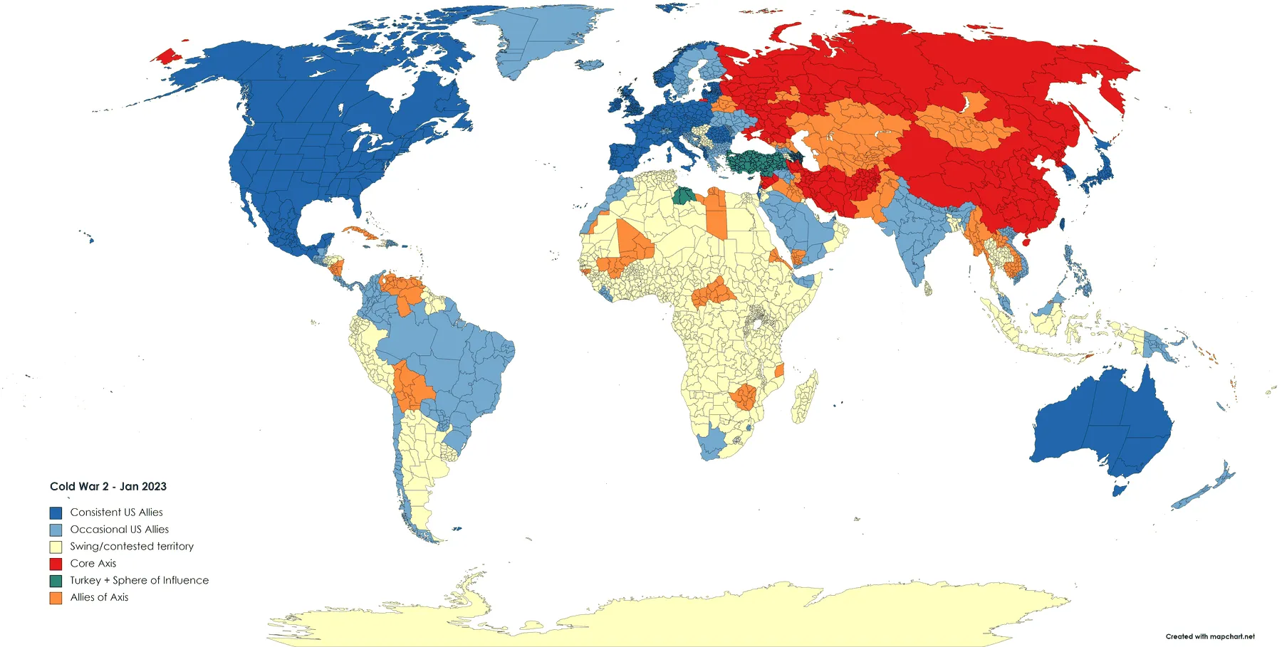
Legend, as drawn Consistent US Allies · Occasional US Allies · Swing/contested territory · Core Axis · Turkey + Sphere of Influence · Allies of Axis
4 June 2023
The tidiest version and, read back, the weakest. Five categories, perfectly symmetric: a Tripartite Alliance of Russia, China and Iran with a ring of allies, a Core West with a ring of allies, and one bin for everybody else.
Symmetry is expensive. Turkey, which had its own bloc in March 2022 and a sphere of influence in January, is here simply Undecided, filed with all of North Africa, the Gulf, Indonesia and most of South America. India moves the other way, from undecided to Western ally, on no evidence I could now reconstruct. This is what it looks like when a model gets prettier without getting better informed.
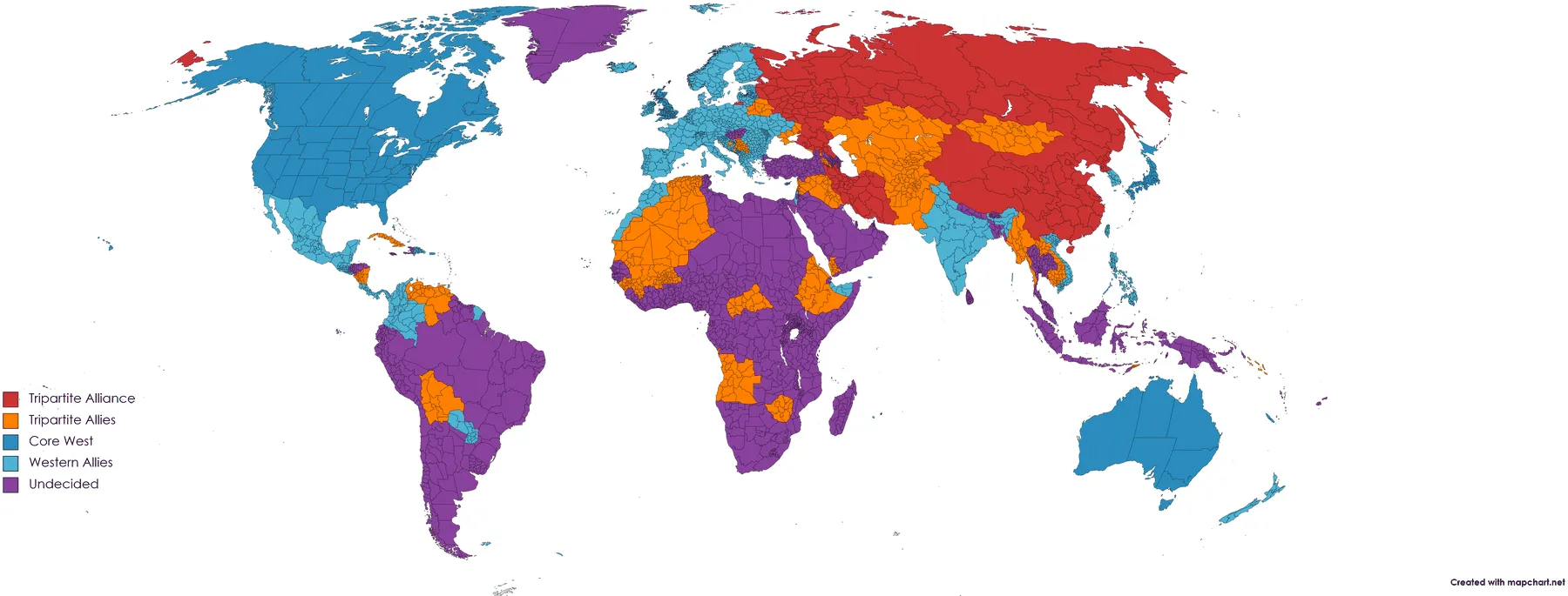
Legend, as drawn Tripartite Alliance · Tripartite Allies · Core West · Western Allies · Undecided
18 November 2023
The symmetry breaks and does not come back. Eight categories, two of them new in kind. The Gulf states get a colour of their own, so a regional bloc can finally belong to neither side instead of being sorted into one. And a crosshatch appears for Islamic State, Boko Haram and al-Qaeda, the first time the map admits an actor that is not a state at all.
This is also the first version drawn after 7 October 2023, and the first in which large parts of central Africa and inland South America are simply left uncoloured. After twenty months of assigning every country to somebody, the map starts leaving blanks, which is the most defensible thing it ever does.
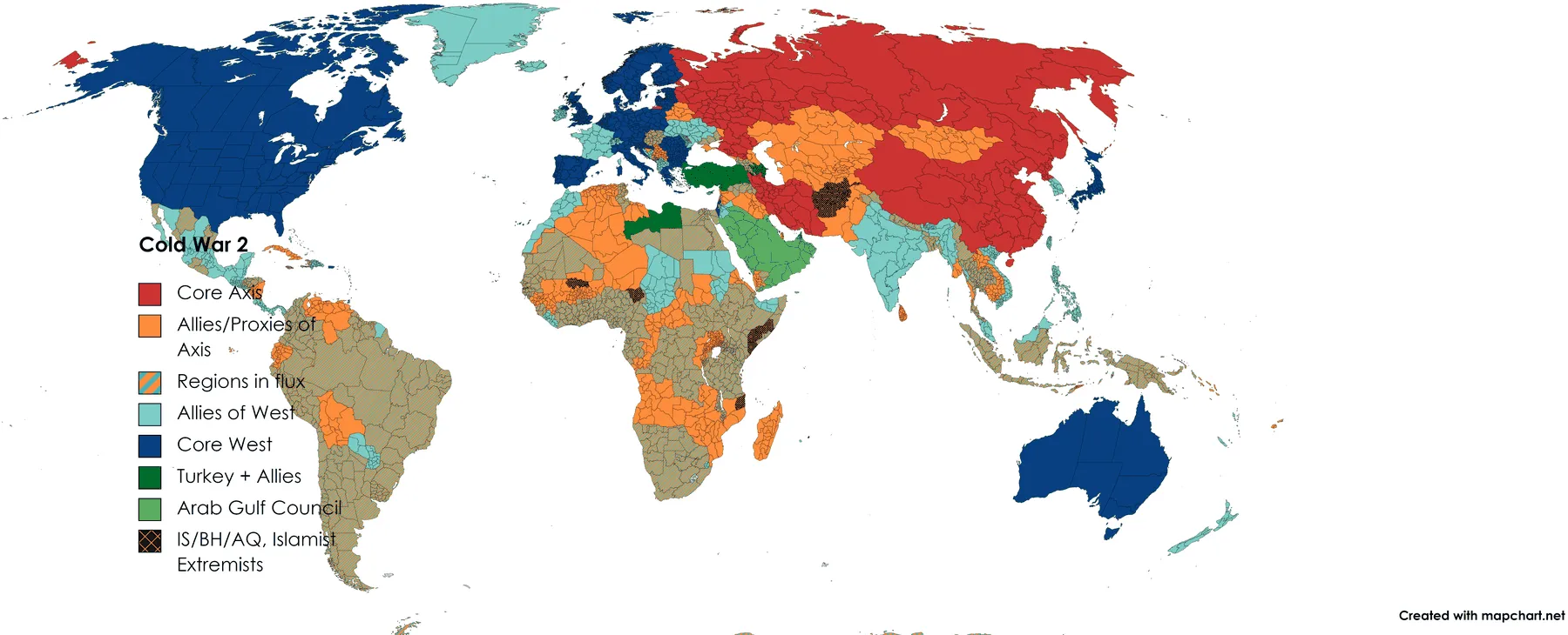
Legend, as drawn Core Axis · Allies/Proxies of Axis · Regions in flux · Allies of West · Core West · Turkey + Allies · Arab Gulf Council · IS/BH/AQ, Islamist Extremists
1 December 2023
Two weeks later, the same eight categories with their names tidied and the legend reordered to run west first: Allies of West becomes Western Allies + Proxies, Allies/Proxies of Axis becomes Axis Aligned + Proxies, and the Gulf council gets its full name.
The substantive change is notation. Regions in Flux stops being a hatch in the axis colour, which had implied that unsettled meant leaning one way, and becomes a checkerboard of the two bloc colours, which says a place is between these two specific things. Small change, better idea.
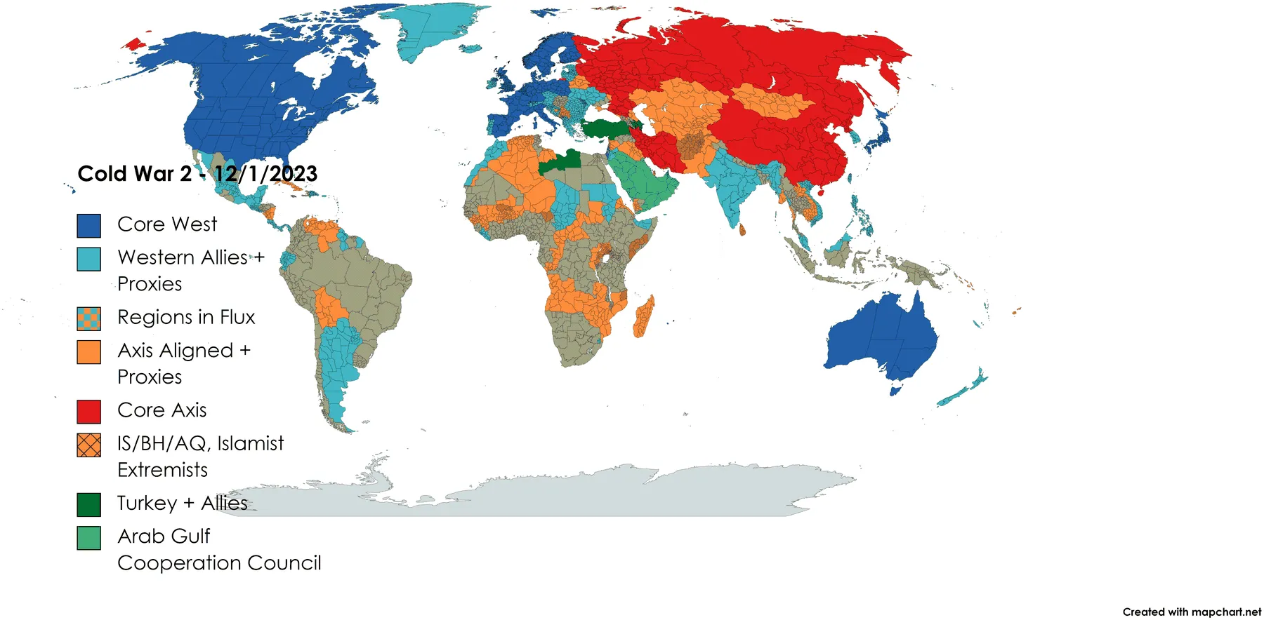
Legend, as drawn Core West · Western Allies + Proxies · Regions in Flux · Axis Aligned + Proxies · Core Axis · IS/BH/AQ, Islamist Extremists · Turkey + Allies · Arab Gulf Cooperation Council
29 May 2024
Nine categories, and the title finally takes a roman numeral. The new category is India, promoted from swing state to a pole with allies of its own. Follow it back: in March 2022 it was Undecided, in June 2023 a Western ally, in December 2023 a Western ally with Ladakh and Kashmir marked in flux, and here it is neither side.
The blanks are gone again. Africa, inland South America, most of Southeast Asia and Antarctica are all under the flux hatch. That reads as progress and I am not sure it is: November's grey said nothing, and this says unsettled about a great many places nobody in the legend is contesting.
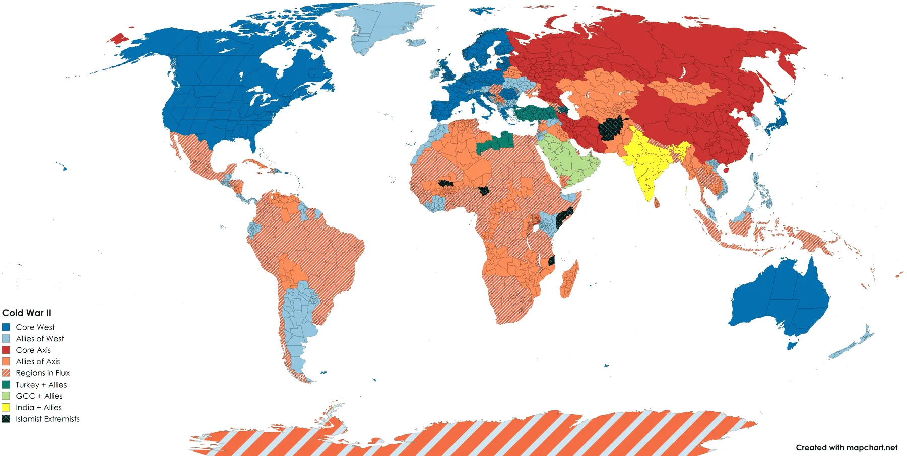
Legend, as drawn Core West · Allies of West · Core Axis · Allies of Axis · Regions in Flux · Turkey + Allies · GCC + Allies · India + Allies · Islamist Extremists
MapChart can save a map twice: once as the picture, and once as a text file listing every coloured subdivision under its group label. One such file survives in the archive, next to the December 2023 sheet. For that one version the map can be counted instead of eyeballed, and everything below comes out of the file rather than off the image.
| Group, in legend order | Subdivisions |
|---|---|
| Core West 18 countries | 452 |
| Western Allies + Proxies 70 countries | 1,081 |
| Regions in Flux 60 countries | 878 |
| Axis Aligned + Proxies 49 countries | 733 |
| Core Axis 4 countries | 155 |
| IS/BH/AQ, Islamist Extremists 6 countries | 49 |
| Turkey + Allies 5 countries | 174 |
| Arab Gulf Cooperation Council 6 countries | 50 |
| Assigned to some group | 3,572 |
In all, 3,572 subdivisions across eight groups, with everything else left in MapChart's default grey. The counts are worth having because they show where the effort went. Most of the assigned area sits in the two vaguest categories, Western Allies + Proxies and Regions in Flux, while the Core Axis that names the whole argument is 155 subdivisions in four countries.
The file also shows something the picture only hints at: 23 countries are cut across more than one group, because by December 2023 the map had stopped treating a country as the unit of alignment. Ukraine is drawn in three pieces, 21 oblasts as western allies, 3 in flux (Zaporizhzhia, Donetsk, Kherson) and 3 as axis-aligned (Crimea, Sevastopol, Luhansk). That is a front line, not an opinion about a country. Syria and Yemen are each cut three ways, along the lines those wars actually ran: Syria's northeast in flux and Idlib and Aleppo under Turkey, Yemen's south and Socotra under the Gulf council while the Houthi north sits with the axis.
And it shows the seam. Regions in Flux is carrying two different ideas at once. In Ukraine it means contested between the blocs the legend names. In Mexico it means these seven states: Nuevo León, Tamaulipas, Chihuahua, Sinaloa, Guerrero, Michoacán, Baja California, which are not contested between blocs in any sense the legend intends. One category doing two jobs is the kind of fault only the data makes visible.
Follow one country through and the arc is legible. In March 2022, a week into the invasion, Ukraine is a single hatched shape marked Undecided with Crimea alone filled in as Russia's. By December 2023 it is 27 oblasts and cities sorted into three groups along the front. The map did not get better at knowing things. It got better at admitting that the unit it had been colouring was the wrong unit.
The same move happens to uncertainty itself. It begins as Undecided, a bin for countries that have not made up their minds; becomes swing/contested territory, which is a claim about somebody else competing for them; reverts to Undecided in the symmetric version; and ends as Regions in Flux drawn as a checkerboard of the two blocs, which at least says which two. Along the way, the November 2023 version does the thing none of the others do and leaves large areas uncoloured. That is the most defensible position on this page, and it lasted exactly one revision before everything got a label again.
What none of this is, is cartography. The projection is whatever MapChart hands you, the palette comes off a swatch grid, and several of the fills are wrong in ways I would now argue about at length. The revision history is the artefact. The maps are only where it happens to be written down.
Six more sheets, in order. They were made for their own reasons and are less interesting one at a time than the series is together, with two exceptions: the supply-chain sheet is the only map in the drawer that says where its data came from, and the last one asks a different question than any of the others.
19 November 2022
Drawn on a Saturday evening in November 2022, thirty-seven minutes before the next one. It is the odd sheet out and probably the best: it asks a question that is not about sides, and it is the only map in the drawer with a source line written on it. Everything else here is a reading. This one you could go and check against Apple's published supplier list.
Whether the categories are right is a separate matter. Mongolia alone carries Sourcing of Materials, which is a lot of work for one country in a supply chain that reaches most of the periodic table.
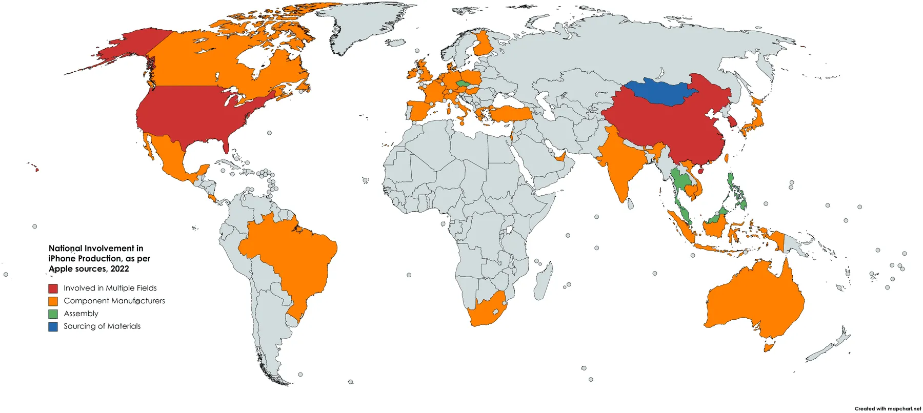
Legend, as drawn Involved in Multiple Fields · Component Manufacturers · Assembly · Sourcing of Materials
19 November 2022
The same evening, and the most defensible alignment map on this page, because its categories are behaviours with public records rather than judgements: did you sanction, did you send aid, how did you vote at the UN.
Its flaw is structural. Those categories are not mutually exclusive, since most states that sanctioned Russia also voted against it at the UN, so each country is shown under exactly one of them and the map ends up ranking the four rather than mapping them. The quotation marks around Russia's "Allies" are in the original.
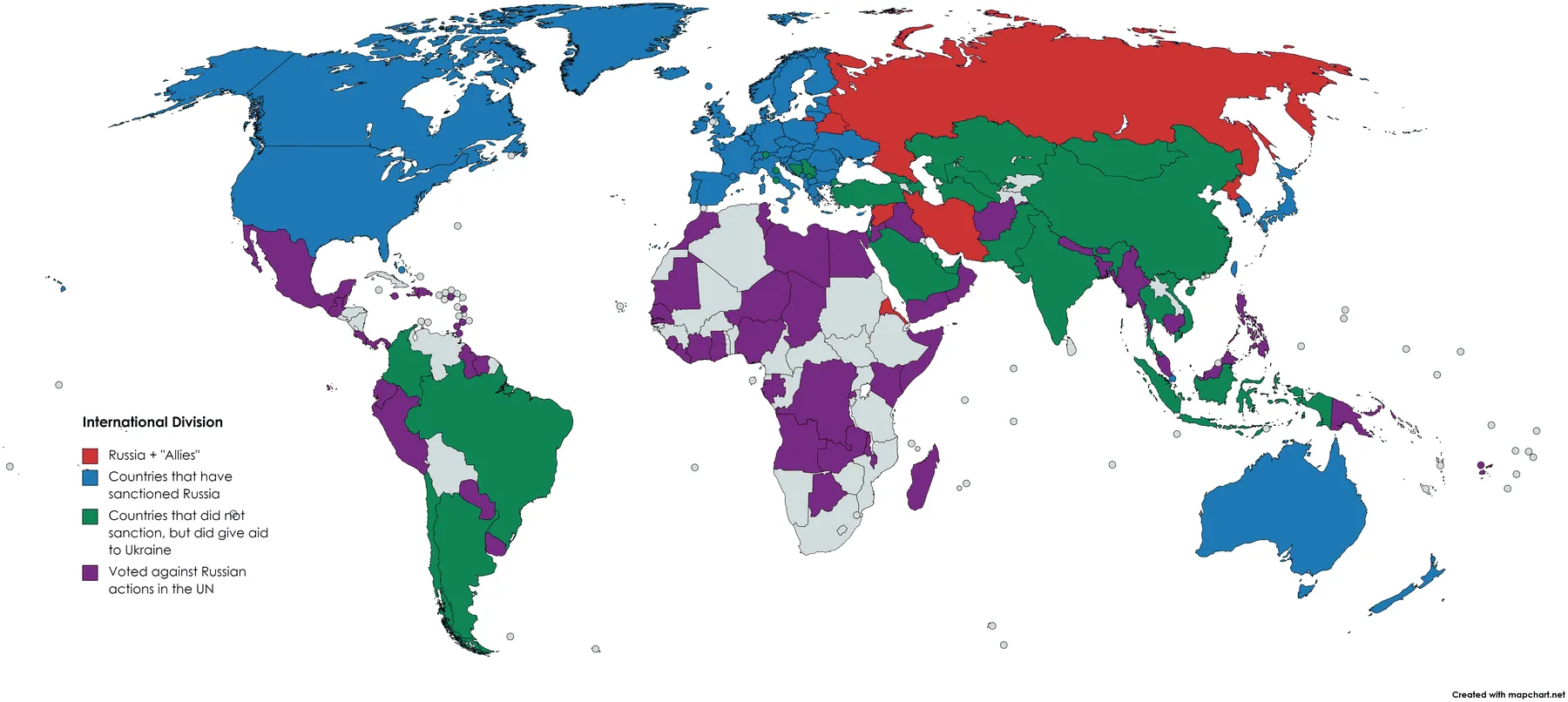
Legend, as drawn Russia + "Allies" · Countries that have sanctioned Russia · Countries that did not sanction, but did give aid to Ukraine · Voted against Russian actions in the UN
23 November 2022
Two craft problems, both worth naming because they are the sort you only see later. The bin edges overlap, so a country at exactly thirty percent belongs to two bins at once. And the top bin is black at the end of a green ramp, which on almost any other map means no data rather than most. There is no source line anywhere on the sheet, so read the numbers as remembered, not looked up.
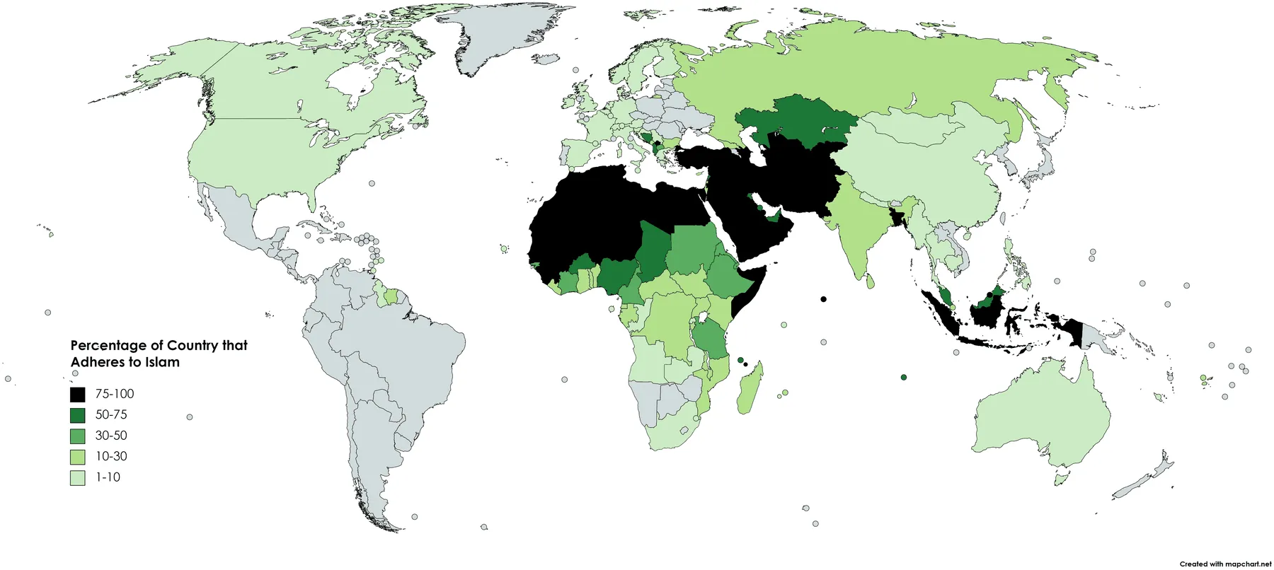
Legend, as drawn 75-100 · 50-75 · 30-50 · 10-30 · 1-10
1 February 2024
No title, no legend heading, no argument: the world cut into the units it seemed to come in. The labels drift between languages, with Italia, Iberia, Sudamerica and El Caribe sitting beside British Isles and Germanic Europe, and Scandinavia misspelled. Warsaw Pact is used as present-tense shorthand for central Europe, thirty-three years after the Warsaw Pact dissolved.
And the granularity gives the game away. The whole of Africa is one region on this sheet. Europe is twelve.
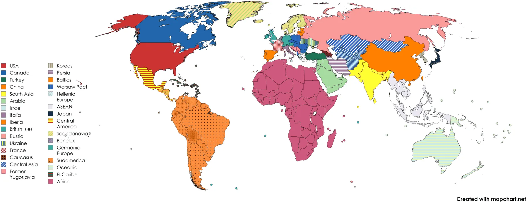
Legend, as drawn USA · Canada · Turkey · China · South Asia · Arabia · Israel · Italia · Iberia · British Isles · Russia · Ukraine · France · Caucasus · Central Asia · Former Yugoslavia · Koreas · Persia · Baltics · Warsaw Pact · Hellenic Europe · ASEAN · Japan · Central America · Scandanavia · Benelux · Germanic Europe · Sudamerica · Oceania · El Caribe · Africa
undated
The last alignment sheet, and the one that changes the question. The axis is no longer whose side a state is on but what it wants from the order it is already in: Establishment, Revisionist, Revolutionary, with Turkey as a bloc of its own and two checkerboards for the places in between.
That reshuffles things a whose-side map cannot. Iran is revolutionary. Egypt, Saudi Arabia and Syria are establishment, including a Syrian government every earlier sheet had filed under the axis. Israel, the United Arab Emirates, Ethiopia and India are revisionist. Whether that carve is right is a real argument, and it is at least a different argument, which none of the six versions of the world map managed to be.
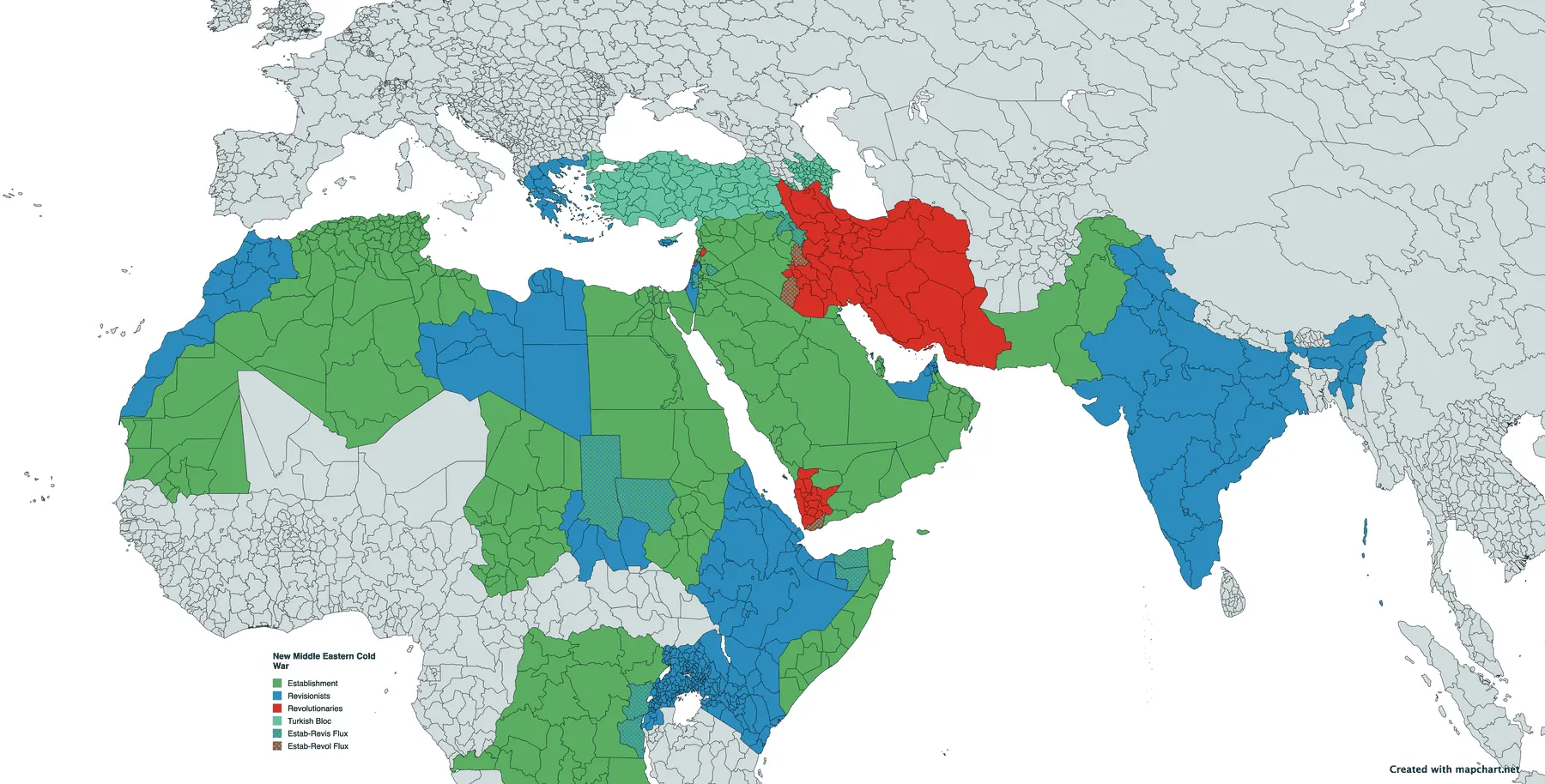
Legend, as drawn Establishment · Revisionists · Revolutionaries · Turkish Bloc · Estab-Revis Flux · Estab-Revol Flux
undated
One colour, one claim, and the only sheet here that is not an argument about somebody else. It also makes the case for keeping the data next to the picture better than anything else in the drawer: this export is zoomed to the North Atlantic, and it silently drops part of what the underlying file records. The counts are below.
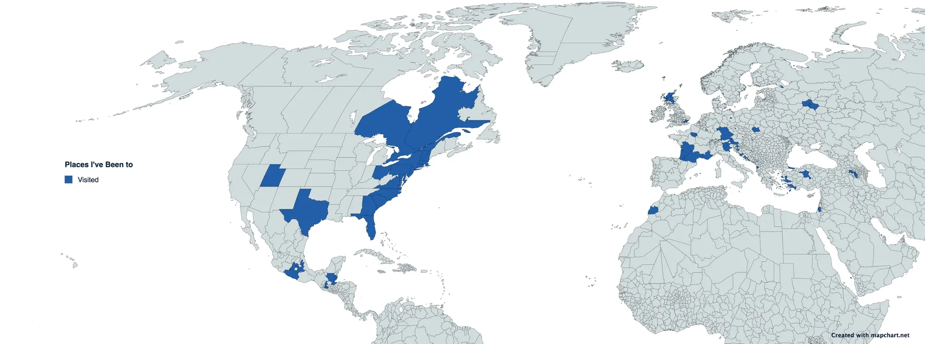
Legend, as drawn Visited
Where they come from. A personal archive of old project folders holds thirteen files and twelve maps: the May 2024 sheet is in there twice under two names, with the same md5 and the same 4,721,809 bytes, saved a minute apart. No extra version of the series is hiding in the duplicate.
How they are dated. By file creation date, which agrees with every date
written into a filename. That settled the one ambiguous case: the sheet called
2nd_Cold_War_04-06-2023 was created on 4 June 2023, so its filename is
day-month, not month-day. Two files were re-saved when the archive was copied in 2026 and
lost their original timestamps. They are the two marked undated above, and their
position in the sequence is inferred from their content rather than known.
The counts. Every number on this page comes from the two surviving MapChart save files, read mechanically rather than counted off the image. The distinction matters more than it sounds. The travel sheet lists 86 first-level subdivisions in 27 countries, but its export is zoomed to the North Atlantic and cuts off around Panama, so the six visited regions in Peru (Lima Province, Callao, Ica, Cusco, Arequipa, Puno) are not in the picture at all. The file is the map. The PNG is one view of it.
Licence and credit. Every sheet here was made with mapchart.net, by Minas Giannekas. MapChart's terms place maps created with it under Creative Commons Attribution-ShareAlike 4.0 and ask for a reference back to the site. Two are carried here: the "Created with mapchart.net" tag is still burned into the bottom right corner of every export above, and this paragraph is the second. Being share-alike, these plates are not covered by the CC BY-NC licence the rest of this site's content carries.
And the obvious caveat. None of this is a dataset. The religion choropleth has no source line, the alignment sheets are a reading of the news, and the regional partition is a set of categories I would not defend now. They are published as what somebody drew, on the day they drew it.